Black Stork Tracks

Migration Maps, Tõnn, Greater Spotted Eagle and Black Storks
Post Reply
Solo
Registered user
Posts: 23861
Joined: October 19th, 2015, 7:18 pm

Re: Black Stork Tracks

Post by Solo »

Liz01 wrote:Karl has made a big trip :2thumbsup: ... it is almost the same route as last year! ...
yes, it is typical for bird, you know Liz :shake:

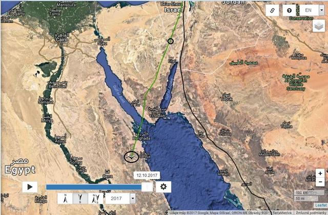
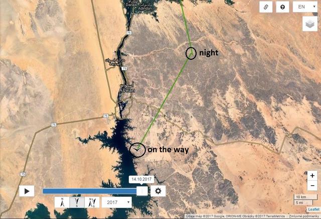
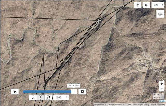
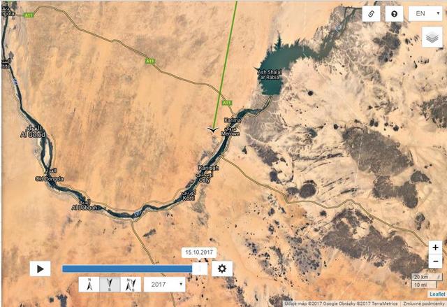
Distance:5077km, Last data: 11.10.2017 + 396km
Image

previous year http://www.looduskalender.ee/forum/view ... 14#p499214
Solo
Registered user
Posts: 23861
Joined: October 19th, 2015, 7:18 pm

Post by Solo »

his route on Sinai is also near the town St. Katherine https://en.wikipedia.org/wiki/Saint_Cat ... ,_2009.jpg
and Mount of Saint Catherine and the Saint Catherine's Monastery https://en.wikipedia.org/wiki/Mount_Cat ... herine.jpg , https://en.wikipedia.org/wiki/Saint_Cat ... i_BW_2.jpg

Image

near his last position (maybe still on the route) was Mons Claudianus https://en.wikipedia.org/wiki/Mons_Clau ... s02_83.jpg

Image

crossed El Gessh - Hurghada route
Image
photo http://static.panoramio.com/photos/large/45181212.jpg
Solo
Registered user
Posts: 23861
Joined: October 19th, 2015, 7:18 pm

Post by Solo »

goris AIVO and MARE

AIVO still no new data (probably he is only out of GSM coverage)

MARE

after 2 days
Image
today - north from Ain al-Nuriyah, Quneitra Governorate (southern Syria, notable for the location of the Golan Heights)
Image
Solo
Registered user
Posts: 23861
Joined: October 19th, 2015, 7:18 pm

Post by Solo »

User avatar
Liz01
Registered user
Posts: 81301
Joined: January 21st, 2014, 2:06 pm
Location: Germany

Post by Liz01 »

Solo wrote: MARE

after 2 days
Image
Solo :hi: the distance is approx 181 km
Image

go to google map.. right click with the mouse - the menu opens- select distance measurement
click on the start point and go to the target point and click again.. I hope it is understandable :bow:

EDIT: https://support.google.com/maps/answer/ ... ktop&hl=en
and for google earth: https://support.google.com/earth/answer/148134?hl=en
Solo
Registered user
Posts: 23861
Joined: October 19th, 2015, 7:18 pm

Post by Solo »

Liz01 wrote:... the distance is approx 181 km ...
Good morning Liz and all,
TY very muche :D

... with the symbol "?" I mean, that we know not exactly Mare's path - they are'nt data (she fly not in so direct line - click https://s1.postimg.org/5z83io9jjz/M_Iskenderun.jpg)
Solo
Registered user
Posts: 23861
Joined: October 19th, 2015, 7:18 pm

Post by Solo »

October 13th

birdmap KARL and EEDI - nothing new

goris AIVO and MARE - only Mare has new data

MARE
Egypt - North Sinai Governorate + 369km

Image

Image

Image
Solo
Registered user
Posts: 23861
Joined: October 19th, 2015, 7:18 pm

Post by Solo »

User avatar
Liz01
Registered user
Posts: 81301
Joined: January 21st, 2014, 2:06 pm
Location: Germany

Post by Liz01 »

October 14

Good morning, Solo and all :hi:

We have new data from Karl :headroll: he is almost at the Nile :2thumbsup:

Image

Image
User avatar
Liz01
Registered user
Posts: 81301
Joined: January 21st, 2014, 2:06 pm
Location: Germany

Post by Liz01 »

Pictures from that area
Image

Image


https://www.google.de/maps/@23.937468,3 ... a=!3m1!1e3

Solo, TY for the update :2thumbsup: :laugh:
Solo
Registered user
Posts: 23861
Joined: October 19th, 2015, 7:18 pm

Post by Solo »

Good morning Liz and all :laugh:

KARL
Aswan Dam (Aswan Governotate, Egypt)
Distance: 5417km, Last data: 13.10.2017 - plus 340km (Oct. 11: 5077km)

Image

probably on the way
Image

photos area where he crossed the Dam: https://ssl.panoramio.com/photo/23240581 (https://goo.gl/maps/TZtTnKTXdFN20) also https://ssl.panoramio.com/photo/80816107 (https://goo.gl/maps/TZtTnKTXdFN2)
Solo
Registered user
Posts: 23861
Joined: October 19th, 2015, 7:18 pm

Post by Solo »

EEDI
Distance: 6532km, Last data: 13.10.2017 - plus 43km (Oct. 12: 6489km)

back to north area
Image

to stream
Image

Image
Solo
Registered user
Posts: 23861
Joined: October 19th, 2015, 7:18 pm

Post by Solo »

User avatar
aquiline
Registered user
Posts: 513
Joined: June 18th, 2016, 11:01 pm
Location: Cologne Germany

Post by aquiline »

Many thanks to all your updates. Beautiful pictures of the areas Eedi and our Karl are staying and relaxing and eating. :loveshower:
I hope they are happy and nothing bad will happen to them.
Solo
Registered user
Posts: 23861
Joined: October 19th, 2015, 7:18 pm

Post by Solo »

aquiline wrote:Many thanks to all your updates. ...
:wave:
Solo
Registered user
Posts: 23861
Joined: October 19th, 2015, 7:18 pm

Post by Solo »

goris AIVO and MARE - 15:45 nothing new :bow:

KATE :unsure: click
Image
Solo
Registered user
Posts: 23861
Joined: October 19th, 2015, 7:18 pm

Post by Solo »

October 15th

birdmap KARL and EEDI
nothing new about Karl - he is probably in Sudan (not enough GSM coverage, quite is also BS Zoltán, HU)
EDIT 11:04 also Karl :D

EEDI
Distance: 6598km, Last data: 15.10.2017 plus 66km (14.10. - 6532km)
back to north - King Fahad Dam area (is enough food this time in the area???)

Image

Image
Solo
Registered user
Posts: 23861
Joined: October 19th, 2015, 7:18 pm

Post by Solo »

from air his currently area (positon) - probably anything else
Image
https://pbs.twimg.com/media/A-GWPqYCcAAKU0_.jpg:large

Bishah/King Fahad Dam and the valley direction north-est
Image
http://s4.postimg.org/ed5im367h/wadi_Bisha.jpg
another view
Image
http://www.bishahtoday.com/wp-content/u ... WA0006.jpg
Solo
Registered user
Posts: 23861
Joined: October 19th, 2015, 7:18 pm

Post by Solo »

KARL
:loveshower:
Distance: 6042km, Last data: 15.10.2017 plus 625km/2 day (13.10. - 5417km)
Merowe - Northern Sudan
Image

Image

KARL 2016:
Image
Solo
Registered user
Posts: 23861
Joined: October 19th, 2015, 7:18 pm

Post by Solo »

Post Reply

Return to “Migration Maps and News”