Following Karls' Families

Migration Maps, Tõnn, Greater Spotted Eagle and Black Storks
Post Reply
User avatar
Anne7
Registered user
Posts: 11248
Joined: April 15th, 2016, 3:26 pm
Location: Belgium

Re: Following Karls' Families

Post by Anne7 »

.
Hello everyone :hi:
Jo :wave:

WABA
Waba's data session failed today.
It is likely that little Waba travelled further south and was in a barely inhabited or uninhabited place when trying to connect. Hopefully s/he will report tomorrow.

Next data session expected: 2022-12-29 at 13:14:21 (UTC+2)


UDU
Today, Udu's transmitter connected and sent us some data but unfortunately no new location points. So we don't know where little Udu is.

I checked Udu's graphs.
Today at 08:25 UTC (= 11:25 local, Turkish time), his transmitter measured an internal temperature of 10°C. That’s not too cold.
The X-Y-Z graphs look OK (as far as one can tell with leg-mounted transmitters).
Battery level: still 0%

Next data session expected: 2022-12-30 at 13:39:59 (UTC+2)

Stay safe and sound, Waba and Udu! And all the others too, of course.
“Clearly, animals know more than we think, and think a great deal more than we know.”
— Irene Pepperberg
User avatar
Anne7
Registered user
Posts: 11248
Joined: April 15th, 2016, 3:26 pm
Location: Belgium

Post by Anne7 »

December 29th
:wave:

WABA
Our Waba sent data. :loveshower:

You will hardly believe what you see. :D

I'll make 2 tracker maps.

The day before yesterday (afternoon) and yesterday (entire day)
▶︎ TRACKER MAP
WABA 27/28.12.2022
From 27.12 at 11:08 until 28.12 at 23:00 UTC
https://www.google.com/maps/d/edit?mid= ... sp=sharing

Battery: 100%
Distance: 240 km


Image

Waba spent the night (27/28) in the Atbarah River, slightly north of the village of Abu Ammar. The water level of the Atbarah River is apparently low at the moment.
Image

Edit:
A recent (28.12.2022) "water body map" of that section of the Atbarah River:
https://up.picr.de/44950159ax.png
Sentinel, Normalized Difference Water Index (NDWI)

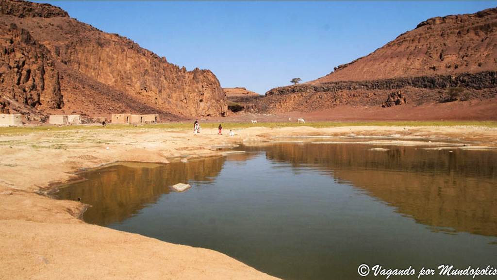
On 28.12 at 09:39 (UTC+2) Waba started crossing the Bayuda desert and found a nice waterbody to spend the next night (28/29). A man-made construction/dike (probably to retain the water) can clearly be seen at that place.
Image

Edit:
The recent (26.12.2022) "water body map" of that place shows that Waba remained on the shallow banks of that reservoir in the desert
https://up.picr.de/44949175fo.png
Sentinel, Normalized Difference Water Index (NDWI)

The basin is located on Wadi Abu Dom
https://up.picr.de/44949259bw.png
Sentinel

The Bayuda Desert, located at 18°N 33°E, is in the eastern region of the Sahara Desert, spanning approximately 100,000 km2 of northeast Sudan north of Omdurman and south of Korti, embraced by the great bend of the Nile in the north, east and south and limited by the Wadi Muqaddam in the west. The north to south aligned Wadi Abu Dom divides the Bayuda Desert into the eastern Bayuda Volcanic Field and the western ochre-coloured sand-sheets scattered with rocky outcrop.
Gold mining occurs today from October to March, as labourers work auriferous quartz found in wadis and shallow mines. These workings are usually in areas previously worked during the New Kingdom of Egypt and the Early Arab Period. In July 2020, it was found that gold hunters had used heavy machinery at the Jabal Maragha archaeological site in the Bayuda Desert, destroying it by digging a huge trench. The gold diggers were arrested and their equipment seized, but they were later released without charges.
https://en.wikipedia.org/wiki/Bayuda_Desert
“Clearly, animals know more than we think, and think a great deal more than we know.”
— Irene Pepperberg
User avatar
Anne7
Registered user
Posts: 11248
Joined: April 15th, 2016, 3:26 pm
Location: Belgium

Post by Anne7 »

WABA

This is a view of the Bayuda desert near the city of Atbara
Image
© ayoub babiker; https://lh5.googleusercontent.com/p/AF1 ... TEfF=h1440

Another view alongside Waba's track across the desert.
“Sudán. Cruzando el desierto de Bayuda”
"Sudan. Crossing the Bayuda Desert".
Image
© Santiago Cordero; https://lh5.googleusercontent.com/p/AF1 ... ydjO=h1440

And this photo is taken very close to Waba’s night area, a waterbody (wadi reservoir) in the Bayuda desert
"Traversée du désert de Bayuda”
“Crossing the Bayuda Desert"
Image
© Olivier Morice
“Clearly, animals know more than we think, and think a great deal more than we know.”
— Irene Pepperberg
User avatar
Anne7
Registered user
Posts: 11248
Joined: April 15th, 2016, 3:26 pm
Location: Belgium

Post by Anne7 »

WABA

Today (forenoon)
▶︎ TRACKER MAP
WABA 29.12.2022
From 00:09 until 11:09 UTC
https://www.google.com/maps/d/edit?mid= ... sp=sharing

Battery: 100%
Distance: 96.4 km


This morning at 09:29 (UTC+2), after breakfast, little Waba continued its flight to the northwest. And this way, Waba is currently right back where s/he left off, on 16.12 (thirteen days ago). :D :mrgreen:

Image

Image

At 13:09 (UTC+2), Waba is flying over the Atmara Alcasinger Island at a speed of 43 km/h, maybe heading towards the banks of the Merowe Reservoir?? 8-)
Image


Edit: Hello Francesca, Hulbi and Fussel! :wave:

What amazes me over and over again is how unerringly BS remember any enjoyable location and how easily they find their way back there without any hesitation. And this even over very long distances.
They possess an amazing memory and flawless orientation skills! :2thumbsup:
“Clearly, animals know more than we think, and think a great deal more than we know.”
— Irene Pepperberg
User avatar
Francesca_V
Registered user
Posts: 2032
Joined: August 11th, 2012, 10:19 pm
Location: Germany

Post by Francesca_V »

Little Waba is unbelievable! :loveshower:
Hulbi Lorm
Registered user
Posts: 683
Joined: August 3rd, 2022, 9:41 am

Post by Hulbi Lorm »

Hi Anne, Francesca and all others :wave:,

so now Waba has obliterated all our theories about how s/he will strictly follow the course of the Nile. :mrgreen:

Interesting choice, that pond / lake looks like a good dinner place. In the end, it's less about where s/he ends up going, and more important that there's enough food on the table every day. No worries in that respect today.
fussel
Registered user
Posts: 128
Joined: October 14th, 2022, 9:03 am
Location: Saxony, Germany

Post by fussel »

Hello everyone :hi: ,

little Waba surprises us again and again. :headroll: First along the river - suddenly across the desert. There she tracks down a lake. Maybe she will visit the Merowe reservoir again tomorrow. Then the circle is closed.

Anne, you are doing a wonderful job and very, very exciting for us. Thank you.

:wave:
User avatar
Francesca_V
Registered user
Posts: 2032
Joined: August 11th, 2012, 10:19 pm
Location: Germany

Post by Francesca_V »

Our Waba has found its favourite place: the Nile close to the Merowe Dam. :thumbs:
User avatar
juta
Site Admin
Posts: 5832
Joined: September 25th, 2008, 1:52 pm
Location: Tallinn, Estonia

Post by juta »

WABA

Tracker map 29.12 at 11.12(UTC) - 30.12. at 11.12(UTC)

Route 164 km
Battery 100%

https://www.google.com/maps/d/edit?mid= ... sp=sharing

Image

Image
Proud member of SHoW (StorkaHolics of the World)
User avatar
Anne7
Registered user
Posts: 11248
Joined: April 15th, 2016, 3:26 pm
Location: Belgium

Post by Anne7 »

Hi everyone :hi:

Thank you, Juta! :wave:

It looks as if Waba wants to make sure everything is still as it was before s/he left on a sightseeing tour.
S/he quickly revisits all known places :D

Waba visited the left and the right bank of the Merowe Reservoir. 8-)
Image

This morning around 09:49 (UTC+2) Waba started to travel southwest along the Nile.
S/he knows this area well.
Image

At 13:09:44 (UTC+2) s/he was already north of Nizeiza, heading in the direction of Affat and Girra Barra, speed 73 km/h
Is s/he eager to see the El Fung Island in the Nile again? :D
Image
“Clearly, animals know more than we think, and think a great deal more than we know.”
— Irene Pepperberg
User avatar
sova
Registered user
Posts: 31108
Joined: October 14th, 2015, 7:11 pm

Post by sova »

*****
For the New Year, I wish you all to achieve all goals, overcome all obstacles and catch all rays of sunshine ! 🍾
User avatar
Anne7
Registered user
Posts: 11248
Joined: April 15th, 2016, 3:26 pm
Location: Belgium

Post by Anne7 »

:wave:

Thanks for your kind wishes, sova!

Wishing everyone a superb 2023!

Image
“Clearly, animals know more than we think, and think a great deal more than we know.”
— Irene Pepperberg
User avatar
Bea
Moderator
Posts: 28962
Joined: January 15th, 2011, 1:02 pm
Location: Bavaria, Germany

Post by Bea »


:wave: Hello everybody!


WABA

▶︎ TRACKER MAP
WABA 30./31.12.2022
From 30.12._11:09 until 31.12._11:09

https://www.google.com/maps/d/edit?mid= ... sp=sharing

Distance: 148 km
Battery: 100%


After the round-trip we can see Waba spending his/her time of the last days of the year 2022 at already well-known places along the Nile, activity between Girra Barra and Gureir

Image

:wave:
Nature does nothing in vain (Aristoteles)
Hulbi Lorm
Registered user
Posts: 683
Joined: August 3rd, 2022, 9:41 am

Post by Hulbi Lorm »

Hi everyone :wave:,

thanks Bea for our final black stork news of the year, and a happy and healthy new year to all of you, and to our feathered friends in Africa (and wherever Udu is right now)! :headroll:

I'm really excited to see what will happen next year!
Treia
Registered user
Posts: 603
Joined: August 11th, 2018, 9:42 am
Location: Finland

Post by Treia »

I wish...
to all of us and our birds
thank you for the past year
and a happy new year 2023 !

Image
User avatar
Francesca_V
Registered user
Posts: 2032
Joined: August 11th, 2012, 10:19 pm
Location: Germany

Post by Francesca_V »

Hello everybody! :hi:

Happy New Year to all! Have a peaceful and healthy 2023!


WABA

▶︎ TRACKER MAP
WABA 31.12.-1.1.2023
From 11:09 until 11:09 UTC

Battery: 100%
Distance: 68,6 km


https://www.google.com/maps/d/edit?mid= ... sp=sharing


Little Waba is making a little excursion into the desert.

Image

Image

Waba's night place
Image

:wave:
fussel
Registered user
Posts: 128
Joined: October 14th, 2022, 9:03 am
Location: Saxony, Germany

Post by fussel »

Hi :hi: ,

to all who are involved with the forum in any way, I wish a happy, peaceful New Year. This also applies to the main actors: the black storks.

Our Waba remains in "sight", that's good. She would already be almost at the South Pole, if she had not always flown there and back. This might be a very interesting encounter: penguin meets black stork. :chick:

:wave:
User avatar
Anne7
Registered user
Posts: 11248
Joined: April 15th, 2016, 3:26 pm
Location: Belgium

Post by Anne7 »

.
Hi! :hi:

Thanks, Francesca! :thumbs:

Hulbi, Treia and Fussel :wave:


Where are you rushing to, little Waba? Do you want to go back to the other side of the Nile's bend, back to Albawga maybe? Why do you fly so much these days?

Waba is west of the Bayuda volcanic field.
Image

Image

Bayuda volcanic field (also spelled Bayiuda) is a volcanic field in Sudan, within the Bayuda Desert. It covers a surface of about 11 by 48 kilometres and consists of a number of cinder cones as well as some maars and explosion craters. These vents have erupted 'A'ā lava flows.
The field rises above a Precambrian-Paleozoic basement that may be a domal uplift. There is little known about the occurrence of volcanic eruptions, but the last eruption has been dated to 1,102 (± 48) years before present.
The volcanic field is located in the Bayuda Desert within the great bend of the Nile, 300 kilometres north of Khartoum. It lies 80 kilometres away from Merowe; there are wells at Abu Khorit and Sani north of the volcanic field. The field was discovered by aerial photography in 1920. Numerous Middle Stone Age and Paleolithic archeological sites are found in the field.
https://en.wikipedia.org/wiki/Bayuda_volcanic_field


The Bayuda volcanic field is located near the center of the Bayuda desert of NE Sudan. The numerous small cinder cones that trend horizontally across the center of the volcanic field in this Space Shuttle image were erupted along a WNW-trending line. Lava flows, one of which was erupted about 1100 years ago, are visible in this image, but about 10% of the vents are explosion craters. Bayuda was constructed over Precambrian and Paleozoic granitic rocks, which form the darker areas at the lower right.
Image by NASA Space Shuttle (Public Domain):
Please click here: https://commons.wikimedia.org/w/index.p ... d=11740618

The Bayuda Volcanic Field (in the distance)
Image
© Vagandopormundopolis, May 2021; https://goo.gl/maps/cwkddT62U5ZWFz1x7
“Clearly, animals know more than we think, and think a great deal more than we know.”
— Irene Pepperberg
User avatar
Anne7
Registered user
Posts: 11248
Joined: April 15th, 2016, 3:26 pm
Location: Belgium

Post by Anne7 »

.
Bayuda Volcanic Field (the El Muweilih Crater)
Image
© Vagandopormundopolis, May 2021; https://goo.gl/maps/MxKUd5gWEHsZ1anX7

El Muweilih Crater in Sudan with natron-rich* clay on the crater floor.
(* Natron - a mineral salt - deposits are sometimes found in saline lake beds which arose in arid environments.)
Image
© https://www.wikiwand.com/en/Volcanic_field

Bayuda Volcanic Field
Image
© Vagandopormundopolis, May 2021; https://goo.gl/maps/phU13jqKHCA7CGVV9
“Clearly, animals know more than we think, and think a great deal more than we know.”
— Irene Pepperberg
User avatar
Anne7
Registered user
Posts: 11248
Joined: April 15th, 2016, 3:26 pm
Location: Belgium

Post by Anne7 »

.

For comparison, two different maps showing the same area

Google Maps:
(I have also indicated the location of the known reservoir on Wadi Abu Dom)
Image

Sentinel (2022-12-31)
Normalized Difference Moisture Index (NDMI):
Image

:wave:
“Clearly, animals know more than we think, and think a great deal more than we know.”
— Irene Pepperberg
Post Reply

Return to “Migration Maps and News”