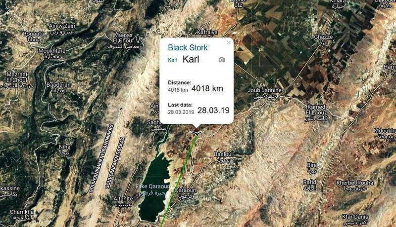
Following Karls' Families

Migration Maps, Tõnn, Greater Spotted Eagle and Black Storks
Post Reply
User avatar
Liz01
Registered user
Posts: 81351
Joined: January 21st, 2014, 2:06 pm
Location: Germany

Re: Following Karl's Family

Post by Liz01 »

Hellem wrote: March 28th, 2019, 2:40 pm 28.03 New update by Karl - 4018 km (+117 km), he sent data near Baaloul (Beqaa governorate) in Lebanon
Thank you Hellem :2thumbsup:


Image

Image

Image


Solo :mrgreen:
User avatar
Liz01
Registered user
Posts: 81351
Joined: January 21st, 2014, 2:06 pm
Location: Germany

Post by Liz01 »

sova wrote: March 28th, 2019, 7:57 am ...........
Yesterday evening I lay in bed with a slight fever.
Dear Sova, get well soon!

Anne, Michi, Treia, Hellem, Solo! Thanks a lot for updates and great pictures :2thumbsup: :bow:

Michi, I like your 3 D pictures. You can almost see as far as Estonia :laugh:

Next week... :shake: :headroll: I hope very much, that Kati is doing well too.
User avatar
Anne7
Registered user
Posts: 11428
Joined: April 15th, 2016, 3:26 pm
Location: Belgium

Post by Anne7 »

:wave:
Liz, thanks a lot for the update! :2thumbsup:

Sova :thumbs:
I completed the second update in yesterday's summary.
Please do not feel obliged to make the next weather reports.
It is more important that you rest well.

Here is Karula's afternoon tracker map
TRACKER MAP
Karula_March28_afternoon
https://drive.google.com/open?id=1M3SwD ... sp=sharing

He made a trip further southwards.
But he didn't like it over there and flew back to the north, to his favourite area.
And then again a little southwards. :D

Image

A trip to the south
Image

Back northwards
Image
“Clearly, animals know more than we think, and think a great deal more than we know.”
— Irene Pepperberg
User avatar
Anne7
Registered user
Posts: 11428
Joined: April 15th, 2016, 3:26 pm
Location: Belgium

Post by Anne7 »

Some photos on KARULA's route

Syrian and Coptic Orthodox celebrate the feast of the Epiphany at the baptismal site known as Qasr el-Yahud on the banks of the Jordan River near the West Bank city of Jericho. It is the traditional site where it is believed John the Baptist baptised Jesus Christ.
Image
Epiphany at the baptismal site known as Qasr el-Yahud on the banks of the Jordan River by Beautiful Faces of Berlin, on Flickr

Aqueduc near Jericho
Image
Aqueduc by mll, on Flickr

Jericho is a city in the Palestinian Territories and is located near the Jordan River in the West Bank.
Archaeologists have unearthed the remains of more than 20 successive settlements in Jericho, the first of which dates back 11,000 years (9000 BCE), almost to the very beginning of the Holocene epoch of the Earth's history.
Copious springs in and around the city have attracted human habitation for thousands of years. Jericho is described in the Hebrew Bible as the "city of palm trees”
https://en.wikipedia.org/wiki/Jericho
“Clearly, animals know more than we think, and think a great deal more than we know.”
— Irene Pepperberg
User avatar
Anne7
Registered user
Posts: 11428
Joined: April 15th, 2016, 3:26 pm
Location: Belgium

Post by Anne7 »

Some photos on KARL's route
So far, Karl flew 4018 km. Today + 117 km (but he is still 'on the road')
Latest known location: near Baaloul, Beqaa Governorate, Lebanon

Image

Sea of Galilee, Israel
Image
Israel - Sea of Galilee by Sara Simmons Photography, on Flickr

The Sea of Galilee is a freshwater lake in Israel. It is approximately 53 km in circumference, about 21 km long, and 13 km wide. Its area is 166.7 km2 at its fullest, and its maximum depth is approximately 43 m. At levels between 215 metres and 209 metres below sea level, it is the lowest freshwater lake on Earth and the second-lowest lake in the world (after the Dead Sea, a saltwater lake). The lake is fed partly by underground springs, although its main source is the Jordan River, which flows through it from north to south.
https://en.wikipedia.org/wiki/Sea_of_Galilee

Lake Qaraoun, Lebanon
Image
Lake Qaraoun in Beqaa Valley by pathaj1916, on Flickr

Lake Qaraoun is an artificial lake or reservoir located in the southern region of the Beqaa Valley, Lebanon. It was created near Qaraoun village in 1959 by building a 61-metre-high concrete-faced rockfill dam (the largest dam in Lebanon) in the middle reaches of the Litani River (the longest river in Lebanon). The reservoir has been used for hydropower generation, domestic water supply, and for irrigation of 27,500 hectares.
https://en.wikipedia.org/wiki/Lake_Qaraoun
“Clearly, animals know more than we think, and think a great deal more than we know.”
— Irene Pepperberg
Summi
Registered user
Posts: 3327
Joined: September 14th, 2009, 11:54 am
Location: Estonia

Post by Summi »

Big thank you to everyone. :wave:
One really becomes educated in geography, architecture, history and culture of different countries while following the migration. This is awsome work you all do here. :2thumbsup:
User avatar
Michi
Registered user
Posts: 3880
Joined: May 4th, 2013, 3:30 pm
Location: Berlin, Germany

Post by Michi »

Hello everyone, :wave:

some pictures from Karls last location in Lebanon.

28.03.2019, distance 4.018 km
Image

The landscape looks very different compared to Israel.
View to north, viewing height is 2,64 km.
Image

Karl is in a wide valley between two mountain ranges. The highest point I could find in Google Earth - if the description is right - was about 2.400 m high.
View to north/north-east, viewing height also 2,64 km.
Image

Thanks a lot everyone for the interesting pictures and reports! :2thumbsup:
Anne, Liz, you're welcome. :)
User avatar
Michi
Registered user
Posts: 3880
Joined: May 4th, 2013, 3:30 pm
Location: Berlin, Germany

Post by Michi »

Karl between the mountains.
View to north/north-east. Viewing height is 13,37 km.
Image

His way ahead.
View also to north/north-east, viewing height 13,85 km.
Image

Edit:
A picture almost from the ground, from 1,23 km height. It's a tiny bit like Karl sees it. :rolleyes:
Image
User avatar
Michi
Registered user
Posts: 3880
Joined: May 4th, 2013, 3:30 pm
Location: Berlin, Germany

Post by Michi »

Summi wrote: March 28th, 2019, 9:11 pm One really becomes educated in geography, architecture, history and culture of different countries while following the migration.
Summi :hi:, absolutely right. :nod: This is what I once told my friend. :D
Special thanks to Anne!
User avatar
Anne7
Registered user
Posts: 11428
Joined: April 15th, 2016, 3:26 pm
Location: Belgium

Post by Anne7 »

Summi :wave:
Thank you. In fact, I just share what I discover myself.
Following these journeys is indeed like being there too. (a little)
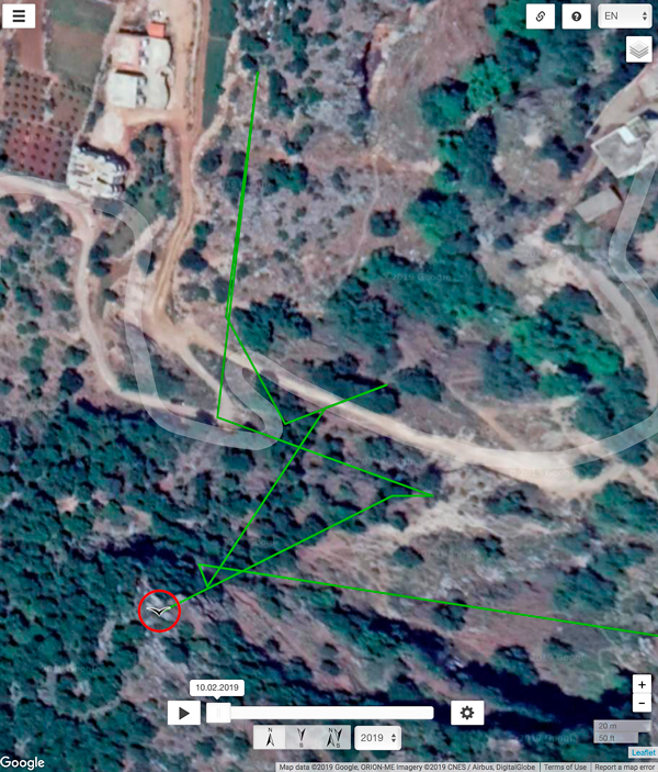
Michi wrote: March 28th, 2019, 9:15 pm Edit: A picture almost from the ground, from 1,23 km height. It's a tiny bit like Karl sees it. :rolleyes:
:nod:
Wow, Michi, your Google Earth views are always amazing! :2thumbsup:
Thanks a lot!

Here is Karula's evening map:
TRACKER MAP
Karula_March28_CompleteDay

https://drive.google.com/open?id=1nb00p ... sp=sharing

He is back "home". :D
Maybe he felt a bit bored today and wanted to stretch his wings.

Image

Image
“Clearly, animals know more than we think, and think a great deal more than we know.”
— Irene Pepperberg
User avatar
sova
Registered user
Posts: 31388
Joined: October 14th, 2015, 7:11 pm

Post by sova »

Good evening everybody
Anne .... Karula's and Karl's data are available.
:wave:
User avatar
Anne7
Registered user
Posts: 11428
Joined: April 15th, 2016, 3:26 pm
Location: Belgium

Post by Anne7 »

sova wrote: March 28th, 2019, 9:31 pm Good evening everybody
Anne .... Karula's and Karl's data are available.
:wave:
Many thanks, Sova :wave:
If I could, I would now serve you a herbal tea with honey and then send you to bed ... :D
Sleep well, Sova :sleeping:


TODAY'S SUMMARY MARCH 28

KARL
Karl's spring migration started in West Equatoria, South Sudan, on 13.03. He appeared on birdmap on 16.03.
The below distance measurement starts on March 02.

Last data: 28.03.2019
Distance: 4018 km (+ 117 km in 1 day), travelling. He sent data near Baaloul (Beqaa governorate) in Lebanon
Weather report on 28.03 in Bet She'an at 10:00
Temp: 20°; (at 15:00 in Jezzîne)
Precipitation: 0 mm; (at 15:00 in Jezzîne) 0 mm
Humidity: 50%; (at 15:00 in Jezzîne) 80%
Air pressure: 1022 hPa; (at 15:00 in Jezzîne) 1019 hPa
Wind 100 m - S/SW (07 km/h); (at 15:00 in Jezzîne) SW (10 km/h)
Wind 250 m - S/SW (07 km/h); (at 15:00 in Jezzîne) SW (12 km/h)
Wind 500 m - S/SW (07 km/h); (at 15:00 in Jezzîne) SW (10 km/h)

MARU
Maru perished on 25.02.2019 at about 13:00, near the Al Ballanah wastewater ponds in Egypt.
Last flight data: 25.02.2019


PÄIKE
No new data (Last data: 07.10.2018)
Last known location: near Schiza Island, Peloponnese, Greece


KARULA
Birdmap was set to spring migration and a new distance measurement started on 15.02.2019 (Total distance on 14.02.2019: 6606 km)
No new data (last data 27.03.2019
Flew a little more southwards and then back to the Tall al Manţaḩ area in the Jordan River Valley.
Weather report on 28.03 in Jericho at 10:00
Temp: 21°; at 15:00 in Masu'a 21°
Precipitation: 0 mm; at 15:00 in Masu'a 0 mm
Humidity: 50%; at 15:00 in Masu'a 30%
Air pressure: 1022 hPa; at 15:00 in Masu'a 1018 hPa
Wind 100 m - S/SW (08 km/h); at 15:00 in Masu'a NW (10 km/h)
Wind 250 m - S/SW (08 km/h); at 15:00 in Masu'a NW (11 km/h)
Wind 500 m - S (05 km/h); at 15:00 in Masu'a SW (05 km/h)

Good night :offtobed:
“Clearly, animals know more than we think, and think a great deal more than we know.”
— Irene Pepperberg
User avatar
sova
Registered user
Posts: 31388
Joined: October 14th, 2015, 7:11 pm

Post by sova »

Anne7 wrote: March 28th, 2019, 9:50 pm Many thanks, Sova :wave:
If I could, I would now serve you a herbal tea with honey and then send you to bed ... :D
Sleep well, Sova :sleeping:

Anne...That's very nice of you ... thank you.
So, now I'm going to bed ... I've also updated cranes.

Liz ... Thanks
:wave:
User avatar
Michi
Registered user
Posts: 3880
Joined: May 4th, 2013, 3:30 pm
Location: Berlin, Germany

Post by Michi »

Sova :hi: , thanks a lot for your work!
I wish you a quick recovery! :2thumbsup:
Solo
Registered user
Posts: 23861
Joined: October 19th, 2015, 7:18 pm

Post by Solo »

KARL - 28.03./4018 km, Karula - 27.03./583 km, EEDI - 27.03./4417 km

Image

Karl: viewtopic.php?p=639621#p639621
Eedi: viewtopic.php?p=639563#p639563
User avatar
Liz01
Registered user
Posts: 81351
Joined: January 21st, 2014, 2:06 pm
Location: Germany

Post by Liz01 »

March 29


Good Morning Anne, Sova, Solo, Hellem and all :hi:
thanks a lot for update and very nice pictures, and also for the information from this area :2thumbsup:

We have new data by Karl
He is near Beit Kahil, is a Palestinian town in the Hebron Governorate in the southern West Bank, located seven kilometers northwest of Hebron.

New Data: Distance 4134 km (+116 km) /( previous data 4019 km)
Image

Jnaid Nabaa esh Sheïkh Jnaïd is a spring(s) and is located in Aakkâr, Lebanon. The estimate terrain elevation above sea level is 1003 metres.
Image
User avatar
Liz01
Registered user
Posts: 81351
Joined: January 21st, 2014, 2:06 pm
Location: Germany

Post by Liz01 »

I found a nice picture near Karl's whereabouts. Picture is from February 19
Image

Image

Overview 2017-2018-2019
Image
Hellem
Registered user
Posts: 24971
Joined: June 28th, 2012, 4:33 pm
Location: Tallinn

Post by Hellem »

:hi:

29.03 New update

Karula - 645 km (+62 km), his/her favourite area near Tal Al-Mantah in the Jordan River Valley
Karl - 4134 km (+116 km), sent data near Bezbina and Beit El Khalil (North Governorate) in Lebanon

Liz :wave:
User avatar
Liz01
Registered user
Posts: 81351
Joined: January 21st, 2014, 2:06 pm
Location: Germany

Post by Liz01 »

Hellem wrote: March 29th, 2019, 9:38 am
29.03 New update
Karula - 645 km (+62 km), his/her favourite area near Tal Al-Mantah in the Jordan River Valley
Karl - 4134 km (+116 km), sent data near Bezbina and Beit El Khalil (North Governorate) in Lebanon

Hellem :wave: thank you. :2thumbsup: I just saw it. New data at our Karula :headroll:

Hellem has already described where she is :thumbs:
Image

Image

Image
User avatar
Anne7
Registered user
Posts: 11428
Joined: April 15th, 2016, 3:26 pm
Location: Belgium

Post by Anne7 »

Hello, everyone
I overslept ridiculously long. :mrgreen:

Liz, thanks a lot for the detailed update on Karl. :thumbs:
That is a paradise-photo.
And thanks for the update on Karula's big splash! :laugh:

Thank you, Hellem, for the new birdmap data. :2thumbsup:
So Karl is still in Lebanon. Next step: Syria. Take care, Karl!

Solo, thanks for yesterday's overview map.

Here is Karula's morning tracker map:

TRACKER MAP
Karula_March29_morning
https://drive.google.com/open?id=1tf3qa ... sp=sharing

:D Back to normal:
Image


KARL.
Another view on his latest known area:
Image
https://goo.gl/maps/Lou24dBWFHT2

Karl's location. I wonder what Karl is doing there? Is he looking for food? Is it his sleeping place?
If this is Karl's night area, he flew 117 + 116 km = 233 km, yesterday.
Image
“Clearly, animals know more than we think, and think a great deal more than we know.”
— Irene Pepperberg
Post Reply

Return to “Migration Maps and News”