Rocks
The Baltic Klint and its colourful rock strata have stood at the sight of the local people already since man arrived in these neighbourhoods on the heals of the retreating glacier, that is, about 10 000 years ago. Rock strata laden with the fanciful mystery of fossils of unseen shapes and the mind-boggling sparkling of crystals – this certainly inspired people to wonder how and when all this has come into being.
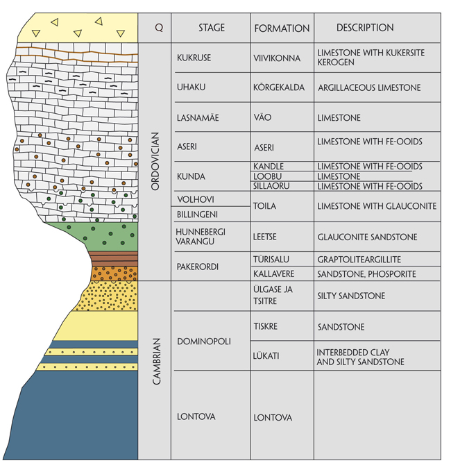
The North Estonian Klint is like an open book that has recorded much of what happened in the region of the future Baltic Sea over nearly 90 million years (540–450 million years ago).
Catastrophes that shocked the Earth, be they an invasion of the sea or ice, collisions of continental plates, volcanic eruptions, earthquakes and meteorite explosions, but also the day-to-day silent murmur of waves and a raindrop fallen on dry sand, the wonderings of wormlets and restless fluttering of molluscs – all this and much else have left their eternal traces in the colourful strata of rocks exposed in the klint. The North Estonian Klint is unmatched among the Palaeozoic rock complexes in the world by its rich and well-preserved fossil fauna. The fossils of the blue clay complex outcropping in places at the foot of the klint bear witness of an explosive rise in the richness of life on Earth about 540 million years ago – the Cambrian evolutionary “explosion”. A rapid divergence of evolutionary lineages of the animal kingdom took place within a geologically short time (app. 10 million years) and by the Mid-Cambrian the ancestors of almost all modern metazoan phyla already inhabited the Earth. The Lower Ordovician rocks in the North Estonian klint zone stand out by their rich colours and diversity. Beneath the grey limestone strata we can find green glauconite sandstone, beige bentonite clay, dark brown Dictyonema shale (argillite) and brownish-grey Obolus sandstone (phosphorite).
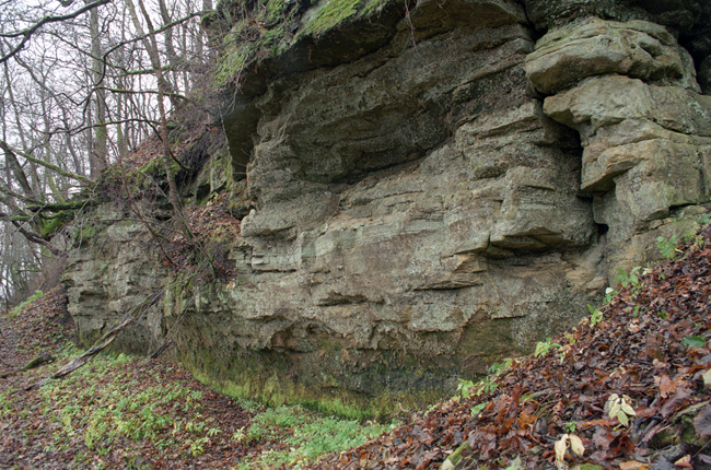
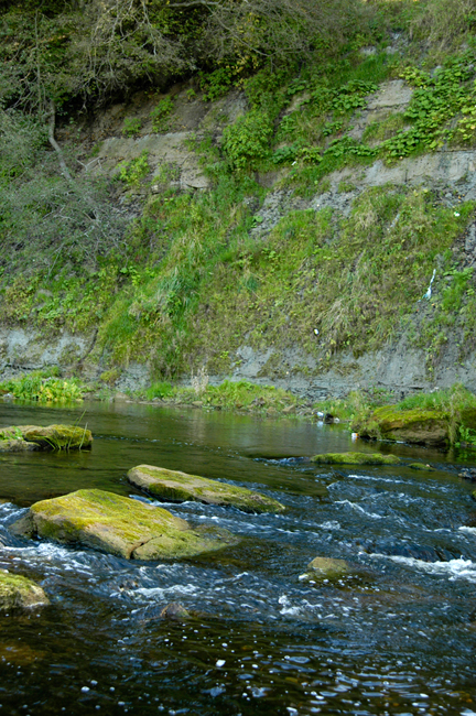
Regardless of the great extent of the North Estonian Klint, the rocks exposed therein are rather similar over its entire length, from Osmussaar to Narva. It is just here, on the North Estonian Klint, that much of what the Baltic Klint has got to offer a geologist or nature lover is represented at its most stately and impressive.
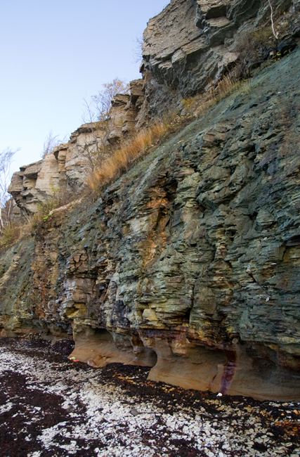
A section of Pakri Peninsula.
1. Kukruse Stage is the youngest of the rock complexes exposed on the North Estonian Klint. Kukruse Stage, known in Estonia as the oil shale bearing complex, occurs on the North Estonian Klint only in the westernmost part, on Suur-Pakri and Osmussaar islands.
Kukersite – the Estonian oil shale.
2. Uhaku Stage belongs to the Middle Ordovician and is represented in the North Estonian Klint by greenish-grey clayey limestone rich in well-preserved fossils and organism debris. Uhaku Stage, whose eastward-increasing thickness is 2–8 m (not exceeding 3–4 m on the klint), is exposed in the upper part of the klint in Northwest Estonia (on Osmussaar, Suur- and Väike-Pakri, Pakri Peninsula, etc.).
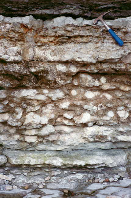
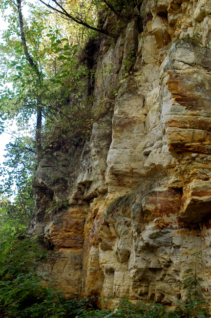
3. Lasnamägi Stage makes up the main (upper) part of the 4–8-m-thick Väo Formation, which is represented in the klint of North Estonia by light grey limestone popularly known as Lasnamägi limestone or building limestone. The upper part of the North Estonian Klint escarpment in the East Harju, Lahemaa and West Harju klint sections is made up of Lasnamägi limestone and this is what has inspired the Estonian popular name of the klint – paekallas (“limestone coast”). Lasnamägi limestone has been mined already since the 12th century from many limestone quarries along the North Estonian Klint, from Pakri to Narva, and bricked into the walls of houses and fortresses. Both Toompea Fortress and Tallinn Town Wall were built of Lasnamägi limestone. A wrecked ship from the 15th century found on the sea bottom at the Danish Straits was loaded with still the same Lasnamägi limestone. Although grey in colour, Lasnamägi limestone with its abundant fossils, discontinuity surfaces, worm burrows and crawling tracks of mud-eaters constitutes a real sight.
Being a hard rock, it can also be smoothed and burnished, which in turn opens the most impressive values of the grey-looking mute stone.
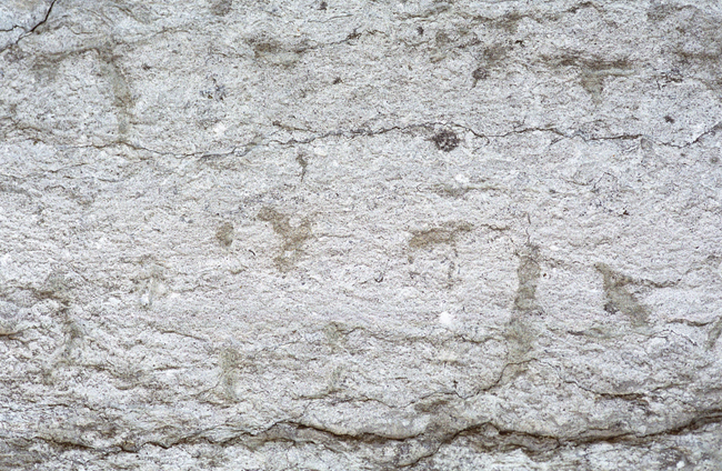
Lasnamägi limestone.
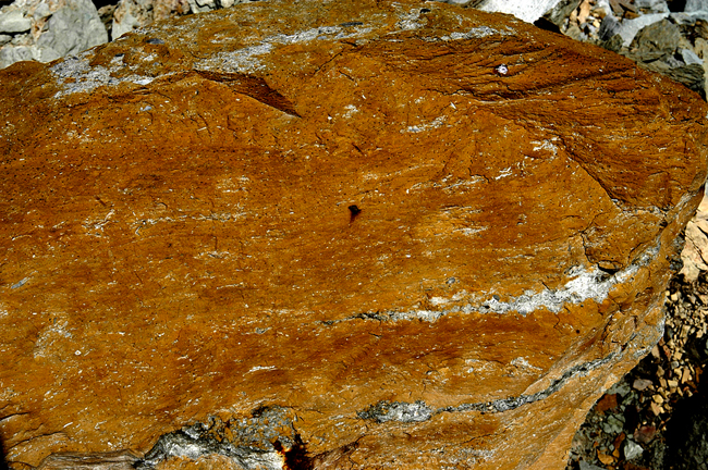
4. Aseri Stage is represented in the North Estonian Klint by Aseri Formation, i.e. iron-ooid-containing limestone. The thickness of the formation decreases from app. 4 m in the eastern part of the North Estonian Klint to 1–2 cm on Osmussaar Island. The stratotype of Aseri Stage is located at East-Viru Klint, on Aseri Cliff.
Iron-ooid-containing Aseri limestone.
5. Kunda Stage is the most complex-structured of the limestone complexes exposed on the North Estonian Klint. Most of the stage is made up of grey limestone of Loobu Formation, which is characterized by a high content of cephalopod (nautiloid) fossils. The thickness of Loobu Formation increases from 0.2 m in the westernmost part of the North Estonian Klint (on Osmussaar) to nearly 7 m in the east. In the eastern part of the klint there is an up to 2-m-thick stratum of iron-ooid-containing limestone (Napa Member) in the upper part of the stage. An up to 1-m-thick complex (1–3 strata) of iron-ooid-containing limy marl (Voka Member) differentiates also in the lower part of the stage. West of Tallinn, Kunda Stage becomes thinner (less than 1 m) and contains sand. Farther west, there appear intermediate strata of clayey oil shale and Pakri Formation emerges. The type section of the latter is the klint scarp on the east coast of the Väike-Pakri Klint Peninsula.
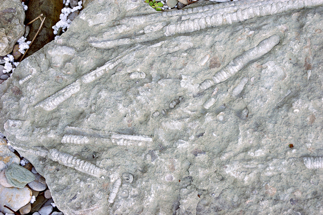
Kunda limestone with abundant nautiloids.
Limy sandstone with kerogene (brown) of Pakri Formation.
6. Volkhov Stage is represented by glauconite-containing limestone of Toila Formation. The thickness of the stage increases from 0.4–0.5 m on Osmussaar to 2.5 m in the easternmost part of the North Estonian Klint. Limestone of Toila Formation is mostly greenish grey but in the easternmost part of the North Estonian Klint (east of Sillamäe) it becomes variegated, that is, such as it is on the Öland and Ingrian Klint. Toila Formation has its type section on Toila Cliff, at the mouth of the Pühajõgi River. Toila limestone contains strata with masses of pygidia of trilobite Megistaspis, but also some well-preserved fossils of the trilobite can be found here.
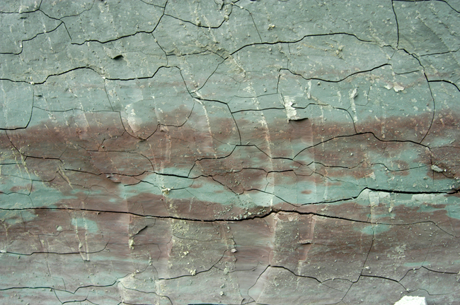
7. Billingeni lademe tüüppaljand on küll Lõuna-Rootsis Billingenis, kuid kihistu levib ka Põhja-Eesti klindil glaukoniiti sisaldava lubjakivi kuni 1,2 m paksuse lasundina (Päite kihistik). Päite lubjakivi on vanim lubjakivi Eesti aluspõhjas, kui mitte arvestada Hunnebergi lademe ülaosas olevat kümmekonna-sentimeetrist glaukoniitlubiliivakivi kihikest. Klindi idaosas on Billingeni lubjakivi kirjuvärviline – Tõrvajõe kirju paas.
Variegated limestone of Tõrvajõgi.
8. Hunneberg Stage, whose stratotype, too, is located in South Sweden, is represented at the North-Estonian klint by green, weakly cemented glauconite sandstone of Leetse Formation. The stratotype of the latter is located on Leetse Cliff on the Pakri Klint Peninsula. The thickness of the formation increases westward from 0.3 m in the surroundings of Narva to about 5 m on Osmussaar. The easily weathering, relatively soft glauconite sandstone underlying a hard limestone complex is what causes the formation of recesses at the foot of klint and leads to rockslide from the limestone complex.
Glauconite sandstone of Leetse.
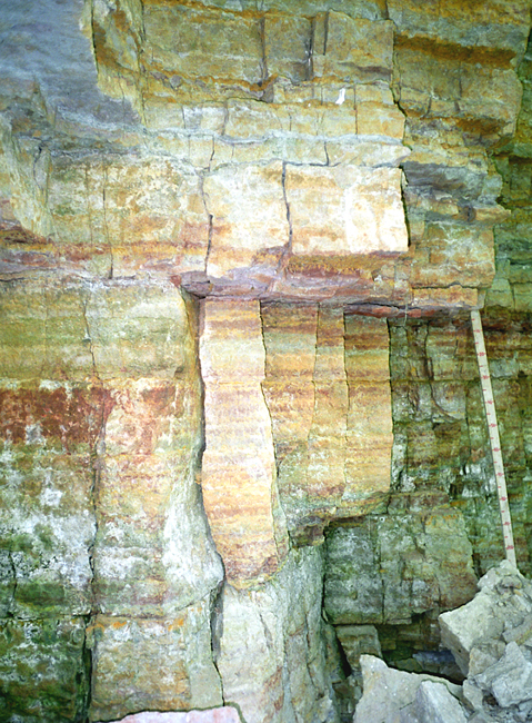
9. Türisalu Formation of Pakerort Stage, whose stratotype is located on Türisalu Cliff on the Türisalu Klint Peninsula, is represented by brown graptolite argillite, popularly known also as Dictyonema shale after the graptolite Dictyonema found in it. Dictyonema shale is, in fact, not shale, i.e. metamorphosed clay, but argillite, i.e. just hardened clay. The thickness of Dictyonema shale decreases east- and southward, from 5–6 m in the western part of the klint until ultimately disappearing near Narva and in Central Estonia, respectively. Dictyonema shale, having an organic content of up to 25%, is a combustible rock of low calorific value and has been used in places as a fuel in lime burning (e.g. on Öland Island). Dictyonema shale contains a considerable quantity of rare metals (Mo, V) and radioactive elements (U, Th). The shale was mined and processed in 1947–1959 at Sillamäe and uranium, too, was separated from the shale here. The usage possibilities of Dictyonema shale have long been studied both in Estonia and in Sweden but so far with no promising results. It is likely, however, that the need for electric power in the coming decades will trigger the need to go for the uranium and other rare metals concealed in Dictyonema shale.
Dictyonema shale at Pakri Peninsula.
10. Kallavere Formation of Pakerort Stage (the phosphorite deposit) consists primarily of Obolus sandstone – mostly weakly-cemented quarz sandstone containing the valves and detritis of inarticulate (hingeless) phosphate-shelled brachiopods (obolides). The valves of obolides contain apatite. Apatite, in turn, has a P2O5 or diphosphorus pentoxide content of 33–36%. The content of the latter in Obolus sandstone is 1–50%, varying both between locations and across the cross section of the formation. Obolus sandstone with a higher than 12% content of obolide valves and detritis (P2O5 content over 4%) is called phosphorite and constitutes a commercial mineral resource. The thickness of Kallavere Formation in the area of North Estonian Klint is 0.1 m (on Osmussaar) to 15 m (at Ülgase) and several potential phosphorite deposits are located here (Tsitre, Valkla, Toolse, Aseri, Narva).
In 1987–88, when ministries of the USSR were planning the establishment of gigantic phosphorite mines in Northeast Estonia together with massive import of foreign labour, which was jeopardizing both the Estonian national identity and natural environment, nature conservation movement united the Estonian society and initiated an overall protest movement against phosphorite mining. These events, known as the Phosphorite War, triggered a rise in Estonians’ national self-consciousness, which later (1991) led to restitution of the national independence of Estonia and indirectly also to the fall of the Soviet imperium.
Obolus sandstone in Ülgase Cliff.
11. Tiskre Formation, whose thickness is 10–20 m and generally increasing westward, is represented by fine-grained, weak- to medium-cemented light grey quarz sandstone of the Lower Cambrian. Its type section is located on Tiskre Cliff in the West Harju klint section. Tiskre sandstone is the main constituent rock of the Cambrian terrace.
Tiskre sandstone in Saka Cliff.
12. Lükati Formation, belonging to the Lower Cambrian, is a transitional rock complex between sandstones and the underlying massive and thick (up to 80 m) complex of blue clay. Blue clay of Lükati Formation, especially in the upper part of the formation, contains several up to 1-m-thick intermediate strata of fine-grained quarz sandstone. The formation is 8–18 m thick, thickening westward. The clays-sandstones of Lükati Formation bear particularly clear traces of the accelerating Cambrian evolutionary “explosion”. It is here that the first brachiopods and trilobites appear next to the cone-shaped shells of the formerly dominating Volborthella (whose origin is problematic). The type section of the formation is located on the bank of the Pirita River near Lükati Bridge.
Type section of Lükati Formation on the bank of the Pirita River.
13. Lontova Formation, which belongs to Lontova Stage and is composed of blue clay, is the thickest (up to 75 m) rock complex in the North Estonian klint zone. Lontova Stage is also the oldest rock complex outcropping in the scarp of the North Estonian Klint. Blue clay got its name from a St. Petersburg-based English diplomat and hobby geologist W. Strangways (1821). Lontova blue clay crops out in several places on the North Estonian Klint at the foot of the Cambrian-Ordovician or Cambrian escarpment but also in clay quarries under the escarpment (Ülgase, Kolgaküla, Kunda, Aseri) or on the banks of rivers cut into the escarpment (Jägala, Selja, Toolse, Kunda, etc.).
Blue clay contains masses of white flattened siliceous tubelets of the genus Platysolenites, which were formerly classified under annelids but are currently regarded as the earliest foraminifers. Blue clay also contains abundant pyritized crawling tracks. It is also the rock underpinning the Estonian structural clay products industry. Blue clay is an illite clay, i.e. fusible clay (melting point below 1100 oC) and cannot thus be used for the production of items with a higher heat resistance inherent to kaolinite clays.
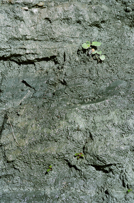
Blue clay of Lontova.
14. Vendian Complex (Ediacara System), which is 40–80 m thick in the North Estonian Klint zone and represented mostly by sandstones and clays, is the oldest (app. 560 million years) of the exposed rock complexes. Vendian rocks do not crop out on the klint but are exposed under Quaternary deposits in several places on the banks of klint valleys and bays and at the sea bottom. The Vendian Complex is differentiated into three formations (in bottom up order): Gdov, Kotlin and Voronka. The film-like formations – Laminarites – found in Kotlin Formation are some of the oldest traces of life in the bedrock of Estonia.
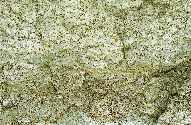
15. Crystalline rocks, which are represented by up to 1.9-billion-year-old strongly folded and granitized metamorphic rocks (gneisses, amphibolites, migmatites, etc.) formed during the Svecofennian Orogeny and app. 1.6-billion-year-old igneous rocks (Rapakivi granites), are bedded in the North Estonian klint zone at the level of 90–140 m bsl. Only on the circular rim walls of the Neugrund Meteorite Crater do crushed crystalline rocks rise to the level of 15 m bsl.

An outcrop of crystalline rocks at the sea bottom on the rim of the Neugrund Meteorite Crater.
