What observation means are there to help ordinary people to predict the weather for the next few days?
Actually one’s own eyes are the best observation instrument; this works quite well when one observes carefully, has a certain amount of stored experiences, and considers the whole of the situation. Of course many measuring instruments are used in meteorology, such as barometers, several kinds of thermometers, humidity and precipitation recording devices etc.; however, they still only register conditions at a given moment, they don’t forecast weather. But of course the data registered by the instruments provide the basis for the official forecasts.
Many have of course seen barometers, and may even have one at home, with marks for fine, changeable, cloudy, rainy, storm etc. This must not be taken too seriously, because even with a low air pressure the weather may be fine, as well as the other way about. But we do get certain information from changes in air pressure. If it starts falling (and was rising or constant before) it can indicate a worsening of the weather but this may not come about before a day or two. This also holds for increasing air pressure. If the pressure remains constant, then the weather will stay more or less the same too. If the air pressure starts changing rapidly in either direction, it indicates the arrival of a new weather type and rising winds.
For measuring winds several instruments are used such as anemometers for wind force, and wind vanes for determining the direction of the wind, but the eye can be sufficient too: the force and direction of the wind can be judged from various objects.
What kind of weather can we foretell from what kind of observations of nature (clouds, wind, plants, animals and similar)?
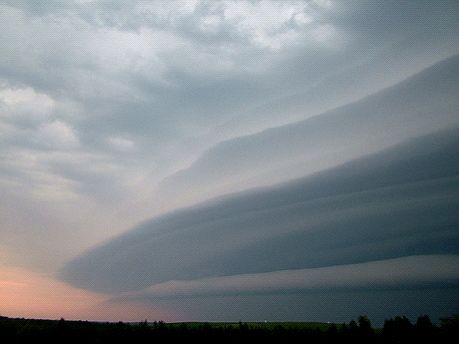
The clouds and wind are the best basis for a short-time forecast. There are clouds in the sky nearly every day, and they reflect the processes that go on in the atmosphere. But predictions of future weather from them are successful only if you observe the sky as a whole and for a longer period, for instance every half hour or hour. Observing a particular cloud, or just glancing at the sky for a moment, can lead to false conclusions because in this way one doesn’t get all of the information needed to make one’s own weather forecast for instance.
There are so many characteristics and marks; here we will only consider some of them. Sometimes strands of cirrus clouds appear near the horizon in a clear sky. They are largely parallel between themselves, but because of the perspective seem to spread out or gather in a fan shape near the horizon, and to have more or less upturned ends. The clouds remind of skis. They are called Noah’s ships; they usually approach rapidly and soon the sky is filled with cirrus and cirrostratus clouds. Usually the weather deteriorates within a couple of hours, and there will be rain within 24 hours at the latest. Of course it may also happen that the low pressure trough or cyclone – which these clouds are tied to –will not exert its full force, and the weather remains cloudy but dry.
Another useful observation is the successive formation of clouds. The formation and thickening of cirrus clouds begins in the west, but may sometimes also come from the southeast or the south. In connection with this a low altitude wind blows at an angle to, or against, the movement direction of the cirrus clouds. This is one of the surest signs that the formation succession has started. Within an hour or so even single cirrus clouds have thickened to cirrostratus clouds; often a halo ring around the sun appears. The cirrostratus clouds thicken quite fast to altostratus clouds and the halos disappear. The sun no longer casts sharp shadows. Later the sun may disappear completely, and it is possible, particularly in the cold period, that there is some light precipitation. At last the clouds are so thick that general precipitation begins.
The colours and shadings of clouds also provide useful information. Here it must be remembered that morning and evening colours differ from those at noon, because of the low position of the sun. If this isn’t taken in account conclusions can go wrong. As a small grain of weather wisdom it can be said that if the clouds come from a direction opposite the sun, then the weather will worsen, and in the reverse case it will become better. This is true for sunset as well as for sunrise.
Many kinds of optical phenomena can be seen in the sky. Rainbows and halos are the best known of them. Most important for forecasts are the rings surrounding the sun or the moon; frequently at the same time coloured spots of light, often with a tail, can be seen at one or both sides of the sun or the moon. These are mock suns or sun-(moon-)dogs. A small ring (22º halo) often means a worsening of the weather because it forms at the level of the cirrostratus clouds, and these again are one stage in the successive formation order of clouds (see above).
Information about weather to come is provided by the direction of the wind, and the relation between the wind direction and the direction of the cloud movement. If a wind direction that has prevailed for several days changes, then a change in weather is imminent. This is tied to the arrival of a cyclone or low pressure area. NB! In spring and summer a light breeze is common in seashore areas; that is, the direction of the wind may change by up to 180º in less than a minute at noon or in the afternoon. This doesn’t as a rule mean a general change in the weather, only locally the air will be cooler and the sky clearer because of the air coming in from the sea. This breeze may repeat from day to day.
If the direction of the wind (excluding the breeze) does not coincide with the movement direction of the clouds then the weather will stay bad, or a worsening is to be expected. If the clouds however move in the direction of the wind then the weather will become better or will stay fine.
There is a great number of observations about plants, animals, health etc, but they are usually not universally valid and often state varying things – that is, their actual association with coming weather is weaker. Some of these observations are valid only in a certain place or if the person using them has an extraordinarily large experience basis. The examples mentioned above are generally valid in the temperate zone, and observing them should be manageable for everyone.
What reasonably simple measuring devices are there to help us to predict the weather and how should we use them?
The burrometer or “weather donkey” is a simple but clever measuring device. It is easy to find instructions for constructing one on the Internet. Basically it is a donkey, made of wood or metal wire, and sitting at the top of a pole. It has a tail made of string or fine rope. This is the most important part, what may be seen as the data transmitter. The basic principles are very simple: when the tail moves, there is a wind, and if it doesn’t, there isn’t, or only a very weak wind; if the tail is horizontal - parallel with the ground - there is storm, and if it is vertical (upright) then we have a tornado; if the tail drips, it is raining; if it is frozen, it is very cold; if it throws a shadow, there is sunshine, and if it isn’t visible, then we have dangerously dense fog or snow or rain blizzard. However, this instrument is not used at meteorological stations: the official instruments are somewhat more precisely calibrated. But all still only show the weather at the moment, not what is going to happen. Measuring devices only register the signals that already exist, that have arrived. Only the changes in air pressure and the rate of the changes, that are seen from observing a barometer, provide information about weather to come (see above).
How long in advance is it possible, with only basic knowledge and devices, to predict the weather (a few days?)?
In nature the corresponding signals form only a few hours up to a couple of days before the arrival of the particular weather or weather type. So air pressure changes as well as clouds usually show the weather 6-12 hours in advance, that is, morning clouds show the day’s weather, and evening clouds the weather in the coming night and morning. Only in particular cases the prediction period can be even longer than 24 hours, for instance in the case of cloud succession events.
Unstable or variable weather is a particular case with its own rules. Unstable weather generally means weather with showers. In that case everybody must observe the situation on their own, all the needed information about precipitation areas and clouds is available on the Internet; from radar or satellite images we can for instance see in what direction the clouds and precipitation move, and we can draw our own conclusions. The problem is that with unstable weather no model or prognosis can predict precisely where and when a shower cloud forms, because the corresponding necessary information in nature appears only immediately before the arrival / formation of the cloud, and so it is only possible to predict that for instance within a day or two this weather type is to be expected.
About models it should be said that they do not take local peculiarities in account, and thus the local weather may differ quite considerably from the prognosis. Because of this everyone should be aware of the characteristics of one’s home area, so that these can be taken in account when looking at or hearing the forecasts. A simple example is the breeze that can change a hot noon day to quite cool within a few moments: a temperature fall of 10 degrees or more within 1-2 minutes is no rarity.
Some models forecast the weather for 10 or more days in advance. One can consider 5 days, but only take a 2-day prognosis seriously because here the butterfly effect appears – small changes in the initial assumptions cause cardinal differences in the final result (7-10 and more days). In making prognoses (meaning official forecasts) signs of nature are not included.
It should also be noted that if signs are contradictory, unstable weather is to be expected or accurate forecasting is not possible, that is, several scenarios are possible.
What should we think of old sayings such as‚ ‘when swallows fly low there will be rain’ and the like?
People of old and sailors have a great number of sayings and observations about the weather. These can be divided into two basic groups: meteorological and non-meteorological. To the first group such observations belong that can be explained scientifically and that are closely connected to the atmosphere.
In the second group there are many different phenomena based so to say on nature (plants, animals, phenology, or some particular sign); they are usually more remotely related to weather but may - but do not necessarily - contain some grain of truth. In addition local observations are separated into general (valid everywhere) and local (usually valid only in a particular place or area).
So there is more truth in the meteorological observations such as those connected to clouds and the wind, and one should consider them more seriously. Plants may also reveal some things. With animals it is very complicated, because many aspects of behaviour aren’t known, or need tens of years of observations of nature, the doings of the animals etc, so if that isn’t there, it isn’t really worth serious consideration. The observations and sayings may also be true where they originated but not elsewhere, or may be correct only during a certain period. Again taking animals as an example, their behaviour depends on an endless number of factors (weather is only one of the variables); in contrast wind and clouds always only form as a result of specific atmospheric processes and conditions, and from this comes their close relation to weather.