Text and photos: Jüri Kamenik
Translation: Liis
In this overview, there are frequently used meteorological terms. If you want to familiarize yourself with them, you might like to use:
http://apollo.lsc.vsc.edu/classes/met130/notes/. There are good and simple explanations about weather and meteorology and I can strongly recommend it.
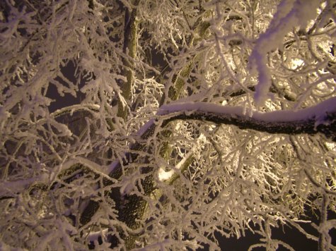
The winter of 2009/10. began in mid-December. To start with there was nearly no snow on the mainland, but a great deal fell on the western and southern parts of the islands. The greatest snowfall was on December 17 around the Bay of Riga where Sõrve tipp and Kolka had 1 metre of snow in 24 hours. The cause was a small low pressure and very cold air mass meeting over a body of open water (the sea). At Sõrve the official depth of snow was still only 41 cm but in Kolka in Latvia it was 100 cm. There was enough snow to last for the whole winter.
Later much snow fell as the result of the combination of the open water effect (lake effect) and low-pressure areas in northern Estonia. The snowfall was particularly heavy on the northern coast at the end of December and the beginning of January. The snow depth finally reached 63 cm, which was a new record for the Tallinn Harku station. The depth decreased later due to winds, compacting of the snow pack and sublimation.
After the Christmas holidays a continuous period of cold days without thaws started, lasting until the end of February. On February 24 a small but active low pressure system with a warm sector passed Estonia and brought thaw to half of the country. The northern parts were as yet unaffected by the thaw, but a few days later it had arrived everywhere.
A summary of the thaw-free period: in Jõhvi it lasted 76 days, the longest of the last winter! The earlier record is also from Jõhvi, from the 1995/96 winter, with 69 days without thaw. The shortest thaw-free period was in Sõrve, “only“ 48 days but for the observation station, this was a record. The over-all longest period without thaws in Estonia lasted 90 days, in the winter of 1941/42 in Viljandi and Ristna.
The snow cover increased until it reached its maximum depth in March according to official data: in north-eastern Estonia it reached over 70 cm.
In March there were also several days with thunder. Thundersnow (a relatively rare kind of thunderstorm with snow falling as the primary precipitation instead of rain) occurred on March 13 and 14. Read more about it at http://www.horisont.ee/node/1566
A very remarkable period occurred in January when there was rime during one week. At its peak the rime extended over thousands of square kilometres, that is, across several countries. The extensive rime cover was further increased on January 11 by fog on the south-western coast, but the weather was still very cold. Within 24 hours however the fog and warmer weather spread over Estonia. This fog too was remarkable for its extent and endurance. Its cause was the arrival of warm and humid air from the north – in Lapland for instance the weather turned to thaw but in Estonia the cold still prevailed, although barely. The rime increased by each day and the deposit was finally several centimetres thick. By January 19 the rime had decomposed but it reappeared repeatedly later during the winter although it did not last as long.
Rime on the evening of January 15 in Tartu
Clear and cold in Nõmme on January 23.
Spring weather arrived already on
March 24-25. In some places temperatures rose to above 10˚C. For instance on March 27 some places had +13˚C. In the evening a
squall line* moved across Estonia from the southwest with thunders and hail. The thunder was favoured by a cold frontier frontline approaching from the southwest. The warm weather continued and warm air advection occurred frequently. On April 1 for instance temperatures were +15 ˚C and even higher in places and it was quite sunny.
Maywas interesting for its contrasts. May 8 for instance was a day with two Estonias: cool and cloudy weather in half Estonia, but hot summer weather in the other half with frequent thunderstorms; read more at
http://www.ilm.ee/?47354 . Although the greatest heat had receded the next day it was hot again some days later and then in all Estonia. On May 13 two weeks of hot and thundery weather began. Not until May 24 the weather turned cool again and more stable. June was mainly cool but very rainy, particularly in eastern and southern Estonia. It is an interesting fact that in many places there was not a single day with thunderstorms excepting June 11, 12 and 30, because only then the weather again turned very warm, even hot and there was thunder in places.
The beginning of
July was warm as usual but in a few days the weather turned hot. In many places there were several days with thunderstorms. On July 8 well developed mammatus (it is a
meteorological term applied to a cellular pattern of pouches hanging underneath the base of a
cloud)could be seen near Põltsamaa. At a mammatus the lower surface of clouds looks as if it were covered by bubbles. Although this is sometimes associated with tornadoes and other similar destructive weather phenomena it must be realised on seeing them that the danger is then already past since a mammatus is seen primarily at the dispersion or receding of cumulonimbus clouds. And so it was on July 8 too.
After this some calmer days with the common mid-summer hot weather arrived. But already in the middle of July a hot mass from western Africa reached the Baltic by way of Central Europe. In many areas in Estonia the maximum temperature rose above 30˚C. On July 15 there were thunderstorms in many places and in some places exceptionally beautiful thunderclouds were noted.
After this the heat receded somewhat but at the end of the month the weather in Estonia was influenced by a high pressure area with its tropical air mass above Russia. Some nights were tropical, that is with minimum temperatures above 20˚C. The night of July 26 was exceptionally hot, with more than 25˚C at midnight and 23˚C in early morning. Since there was much energy in the atmosphere, a thunderstorm system developed over Latvia that night and moved towards northwest and strengthened. In early morning it reached Tallinn, but was then already weakening and it didn’t produce much more than a strong wind and a tremendous scenery
July 29 too was very thundery. The day was interesting because firstly it was much cooler than the previous day and secondly, windy and with low-moving, thrashed cloud remnants to start with. In such weather thunderstorms are obviously not to be expected but the more towards evening the more cumulonimbus clouds were formed and in the evening the greater part of Estonia had had its share. Thunder, somewhat less but still there, was left even for the remaining final days of July.
The first half of August was similarly hot and often with thunderstorms. In the morning of August 8 a powerful thunderstorm system moved over western Estonia bringing hail with it and sending the temperature below 10 C. The day was calm in the whole of Estonia, but in the evening a derecho, or system of specific thunderclouds, moved across the country in two hours. It brought destruction in many places. In the tail of this system numerous more thunderclouds moved to eastern Estonia where some of them brought more but milder destruction. In the evening very intense thunderstorm cells developed in Latvia and the Gulf of Riga bringing again strong thunderstorms to the islands. On reaching the mainland however they dissipated.
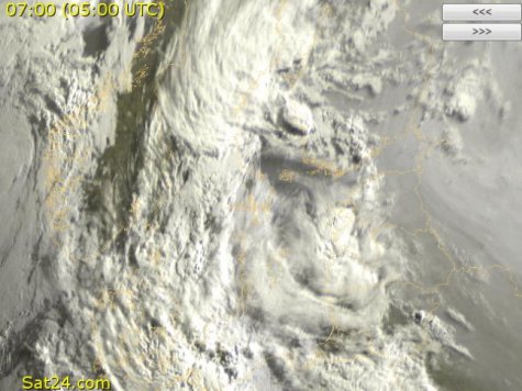
Ü
Super-powerful thunderstorm centre in the morning of August 8. It also brought hail.
Source: Sat24
August 15 was similarly an extraordinarily thundery day. Almost tropical air reached Estonia and already in early morning substantial thunderclouds arrived to the West Estonian islands. During the day they moved across the whole of Estonia and grew more intense in the afternoon above eastern Estonia. Beyond Lake Peipus the force of the thunderstorm system again reached a level comparable to a derecho; Estonia barely escaped a destructive storm. Before the arrival of the storm the temperature was over +34˚C . In Estonia too there was 32˚-33˚C before the storm came.
August 17 was the last unusually thundery day; at the same time it was very hot. I was in Hiiumaa during the day. When I returned on the car ferry the weather was truly summery, very warm and with only little wind. There were few clouds in the sky, with low clouds mainly above Hiiumaa, and the sky was hazy streaked. During the trip I noticed, on looking towards Pärnu, an orange cloud (the sun was setting) which was very beautiful and had a collar of cirrus clouds. It moved straight on to us; looking for more information I found out that it was a powerful thunderstorm over Pärnumaa. Just before we arrived at the mainland harbour the first flashes of lightning appeared and I decided to get a little bit away from the harbour, into some dark but open spot, to observe the lightning. During the first hour the flashes of lightning were distant and struck the ground but when the thunderstorm approached the flashes twisted on the cloud surface or lit up the whole of the clouds (the anvil crawlers and the intracloud lightning). There was no rain and it was warm so the circumstances were in every way comfortable for observing the thunderstorm. The display was awesome, there were tens of lightning flashes; finally one more cloud section arrived, seemingly somewhat from seawards, with even more lightning; it started to rain and finally the thunderstorm slowly weakened. The thunderstorm lasted altogether for about 3 hours. There was a little wind in the beginning but in general it was calm. It seemed that the thunder mostly took place over Hiiumaa, the display there was even more spectacular; I myself was at the edge of the storm. Later it turned out that the Hiiumaa people were not after all hit by very much thunder, so obviously the storm stayed somewhere over the Väinameri - the straits between the mainland and the islands.
August 18 was cloudy and in some areas very rainy. In many places weak thunderstorms occurred too, but lightning struck between clouds and wasn't visible. Northern Estonia escaped more heavy rain and thunderstorms. From then on the weather was already only moderately warm, or even chilly and with an autumny air. Only on some occasional days the temperature went up to near +20˚C. It was often windy with showers. In the evening of August 22 there was a weak but interesting thunderstorm. The weather was cool with low clouds. Nothing indicated thunder. Then the clouds in southwest suddenly changed, a dark cloud edge moved on overhead. The sun was just setting and coloured the western sky a deep red. Suddenly a reddish lightning flash struck overhead. A few minutes later there were a couple of flashes more. At the same time thunder was heard. When darkness fell somewhat more intense thunderstorm moved from southwest over the eastern part of sky. When the clouds disappeared there was a starry sky overhead and the moon illuminated the tops of the cumulonimbus clouds.
Septemberwas quite ordinary. The exceptionally beautiful weather on September 24-25 was remarkable. It was almost uncomfortably warm, and calm and sunny (quite stuffy weather). This however ended already on September 26; after that the weather was autumny.
In
October snow fell several times. The first time was on October 12, with the greatest snowfall on October 22, brought on by an active but small low pressure system that moved straight across Estonia. The snow didn’t remain on the ground. In the next night there was thunder, see more details at
http://www.ilm.ee/?48027.
Novemberwas warm to start with and snow seemed far away. Several times exceptionally well formed jet streams developed over Europe due to the large zonal temperature contrast,
http://www.ilm.ee/index.php?48110 .
In the middle of the month a short wave (
http://apollo.lsc.vsc.edu/classes/met130/notes/chapter12/long_short_wave...)developed on the polar front, so massive that it pushed late summer warmth briefly even to Estonia; so for instance record high temperature was noted in Tartu on November 15. In places it was up to + 13˚C . The next night a storm suddenly rose since a polar front passed again in the evening and behind it swept, at a whistling rushing speed, cold air into Estonia. Ordinary autumn weather followed after this. In the night of November 18 an active warm front moved across Estonia. In relation with this up to 20 cm of snow fell but it melted. A lasting change towards winter occurred on November 24, when the weather turned cold accompanied by snowfall and blizzards.
At the end of November the weather inland was cold (down to -27˚C), on the northern coast much snow fell due to the lake effect. In December extensive mid-latitude cyclones brought large amounts of snow everywhere, there was thundersnow and in the last days of the month the snow cover had grown to a depth of up to 75 cm. Actually there was 50-70 cm of snow already at the end of November in some areas on the northern coast but the snow at the weather observation stations did not reach such depths. On the last day of the year winter had already lasted for more than a month.
Sven-Erik Enno’s summary of the 2010 weather : http://www.ilm.ee/?48336
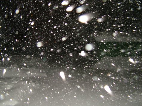
Snowsquall with thunder in the evening of December 4 in Tallinn.
A line of sudden, sometimes violent thunderstorms that develop on the leading edge of a cold front. Squall lines can form up to 80 to 240 km (50 to 149 mi) in front of an advancing cold front and can be more than 160 km (99 mi) long. The thunderstorms of a squall line can produce severe weather conditions, such as hail and rain accompanied by winds of over 96 km (60 mi) per hour; they are also associated with tornadoes, especially in spring and early summer.